
Nationwide Project monitoring for landowner-side counsel

See which parcels a proposed route could affect before final approval.

Allodial tracks infrastructure Projects nationwide and reconstructs public route records into one counsel-ready model. Where Parcel coverage is available, it joins the alignment to county Parcels, recorded owners, available title evidence, and source receipts—so counsel can evaluate the available Project set before intake begins.

Verified read

Project records
553
State records
48
County records
1,523
Condemnor records
270

Why earlier visibility matters

Allodial brings Project-level visibility to landowner-side eminent-domain counsel earlier.

Condemnors plan the Project as a system.

They work from the alignment, affected tracts, title and appraisal files, and an owner-contact plan — before anyone is called.

Landowner-side counsel see that same Project one owner at a time, after outreach or an offer.

Allodial gives counsel the Project-level view earlier.

96%+

of Parcels in the working scenario are not modeled as represented.

Reference Project 500 affected Parcels
≈19 modeled represented ≈481 not represented in model 1 cell ≈ 5 Parcels

Working capacity model: 500 affected Parcels and current close-rate assumptions. This is a capacity thesis, not an observed national representation rate.

01 The information gap

The condemning authority sees the whole taking. Most firms see the first caller.

By the first owner call, the route, tract list, title work, and acquisition plan may already exist. Allodial helps counsel see that Project earlier.

The preparation window

The authority starts early. Counsel usually starts when the owner calls.

Public route records can expose the Project sooner.

  1. 01Route appearsDocket, plan, or final order
  2. 02Tracts preparedParcel, title, appraisal
  3. 03Owner contactedOffer or ROW outreach
  4. 04Counsel calledConventional intake begins
View held by 01Route work 02Parcel plan 03Appraisal 04Owner contact 05Counsel intake
CondemnorProject originator
Working alignmentProject-wide
Affected tractsOrganized as a set
Valuation workPrepared internally
Acquisition planOutreach sequenced
Project context heldAlready in motion
Conventional firmReactive intake
Outside the viewNo matter yet
No Project listParcels stay disconnected
No shared fileAuthority works upstream
Authority moves firstOwner contact begins
One caller appearsOne Parcel defines the view
Allodial firmProject prepared earlier
Route monitoredPublic signal captured
Available Parcels joinedProject set takes shape
Public context attachedNo valuation opinion implied
Project visibleBefore the first intake call
Matter starts in contextOne owner within the whole
Research anchors MnDOT describes 18–24 months from final limits to possession; one Grain Belt sample letter followed CCN approval by ≈14 months. Illustrative—not a national clock.

Project corridor model

One route. The identified Parcel set. Before the first intake call.

Choose a Project preset to inspect how route and Parcel intelligence changes before counsel opens a matter.

1 / 3 Project presets

Interactive schematic. Drag to orbit the route and choose a Project preset above.

Project 57115 selected.

Actual Project data

57115 uses an anchored digitization of CPS Energy’s published Route Y Modified map and 494 Bexar CAD footprints. Presets 59475 and 55728 demonstrate model states; their viewport geometry is illustrative. Terrain, towers, and take geometry are not survey-grade.

02 Beyond the route model

Watch the whole Project while it is still public record.

Allodial helps counsel detect the Project, understand the public record, and see the surrounding market before a single-owner intake defines the view.

Surface 01

Project watch

553Projects

Every public stage change lands on the Project record with the date it happened.

  • Route filing postedProposed · Jul 18
  • Order enteredApproved · Jul 29
  • ROW notice surfacedAcquiring · Aug 04
See the next stage before the first owner call.
Surface 02

Case + offer context

270Condemnors

Available case, offer, and docket records stay attached to the Project they describe.

  • Public filingdocket-linked
  • Offer recorddated
  • Case eventsource-attached
Read the taking party’s public posture per condemnor.
Surface 03

Firm market

48States

Landowner-side firm presence sits beside every tracked Project—held or still open.

  • Howard Road → San Miguelapproved · source-linked
  • Bell County East → Big Hillcandidate routes
  • CPS Energy SAT15Route H · prototype
See which Projects are open before choosing where to build.
Surface 04

Source receipts

1,523County records

Route geometry, county joins, owner names, and title evidence each keep their own provenance.

  • Route sourceattached
  • County recordjoined
  • Owner recordavailable
Every figure opens the record behind it.

03 National Project coverage

The model is built. 553 Projects are in it today.

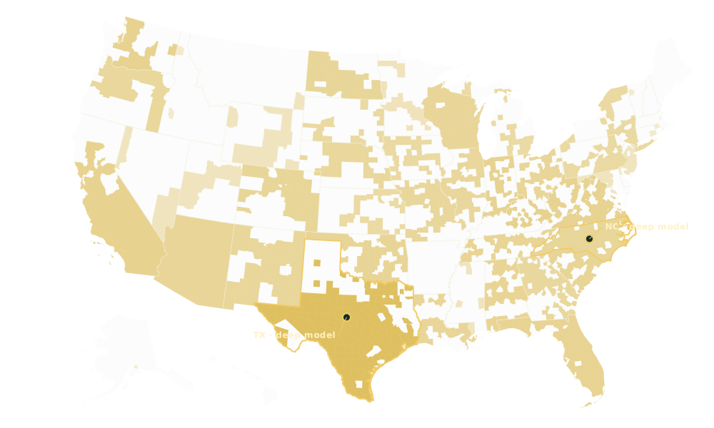
Gold marks county records that resolve to U.S. geography. Stronger gold means more Projects named to that state. It reflects what has been recorded, not demand, case value, or a forecast.

Verified model read · August 4, 2026. Deep Route, Parcel, owner, and title coverage appears where source records have been joined.
United States map plotting Allodial county records in gold. Texas and North Carolina are outlined as deep Route and Parcel model examples.
County record plotted More Projects named to state Deep model example
553
Projects, each one a filed route
1,523
counties, joined to real geography
270
condemnors, named and tracked
1,495 county records match canonical U.S. county geography; 1,469 unique county shapes are plotted. State intensity uses 533 Project records with named-state metadata. Nothing unlocated is inferred onto the map.

04 What counsel actually sees

The three views counsel works in.

Move from national Project discovery to one route and then into the counsel workspace without losing the public record that supports the work.

National market · 01

Find the Project first.

Scan tracked infrastructure work by geography, type, and public stage. Open the Project that matters before a single tract becomes the whole story.

Allodial / Market
Allodial Market interface showing infrastructure Projects across the United States
Actual Allodial product capture · interface and data continue to evolve. Swipe to inspect →Open full size ↗
Project watch · 02

Every public stage change, dated.

Open a tracked Project, follow its current public stage, and inspect available Parcel records without detaching the route from its source history.

Allodial / Corridors
Allodial Corridors interface showing tracked Project stages and route-level detail
Actual Allodial product capture · Project-level depth varies with available source records. Swipe to inspect →Open full size ↗
Operating desk · 03

Keep market, Parcel, firm, and evidence work in one place.

Use one operating view for the Project work your team controls, with the market context still visible around it.

Allodial / Dashboard
Allodial operating dashboard for Project, Parcel, firm, and evidence work
Actual Allodial product capture · shown as a product interface, not a representation of legal advice. Swipe to inspect →Open full size ↗

05 Choose the commercial path

Buying one Project looks like this.

Every price is a fixed fee—never a percentage of your fee or the award. Allodial is a Turbo product; Turbo is the contracting and billing entity. Below the worked example: the two license paths.

Composite Project view · what the unlock deliversRoute approved · source-linked
Project 57115Howard Road – San MiguelBexar County, TX345 kV · Route Y Modified

The day you unlock it, you hold the whole affected set.

  • Mapped Parcels, actual Bexar CAD footprints494
  • Recorded owner names412
  • Filed route miles, digitized from the published map49.06
  • Other firms licensed this Project during your term0

No list-building, no records requests, no tract-by-tract assembly. The set exists before your first owner conversation.

  1. 01
    Unlock

    One fixed payment. Turbo stops licensing this Project workspace to any other firm for the signed term.

  2. 02
    Work the set

    494 Parcels, 412 owners, every figure opening its source record—yours alone to prioritize.

  3. 03
    Represent

    The posted Parcel Price is charged only when an engagement is signed. Fixed, visible beforehand, never a share of anything.

License 01

Access

Fixed monthly · non-exclusive Any firm. Any state. The dataset as a tool.
  • Tracked Projects and public-stage monitoring
  • Mapped Parcels and recorded owners where available
  • Source context retained with the Project record
Request a private preview Turbo is paid only the subscription. No payment is tied to a matter or result.

License 02

Project Exclusivity

One named Project · one fixed exclusive term Turbo stops licensing that Project workspace to other firms during the signed term, subject to written carve-outs. The license holder may admit approved participating firms through its hub.
  1. 01

    Project Unlock The Project account pays Turbo one fixed amount in the signed schedule. Paid once.

  2. 02

    Posted Parcel Price A fixed dollar amount for every Parcel, visible before representation.

  3. 03

    Representation trigger The Project account is charged once when the license holder—or a participating firm it admits—signs an engagement to represent that Parcel’s landowner on the named Project.

  4. 04

    Hub view The license holder sees each admitted firm, the Parcels it represents, and required reporting status. Turbo uses that same representation record to administer the posted Parcel Price.

Discuss one Project $0 monthly. $0 seats. Turbo receives 0% of any legal fee. The signed schedule controls.